 vesseltracker.com
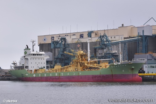
SEAVEN SKY
Current StatusLive Vessel SEAVEN SKY Analytics (details, animations, etc.)
Where is the vessel?
SEAVEN SKY is currently in Near RIO, based on AIS data received about 1h ago.
Latest AIS update:
Current position: 38.31236° N, 21.79214° E (Near RIO)
Vessel profile: SEAVEN SKY is a Cement Carrier with dimensions 117m x 19m.
This page combines live AIS, route history, probable destination signals, nearby traffic, and port activity for practical vessel monitoring.
The current position of vessel SEAVEN SKY is 38.31236 lat / 21.79214 lng. Updated: 2026-03-25 06:01:08 UTCNearest reference points:
- Near Káto Achaïa
- Near MESSOLOGGI
- Near Meganísi
Currently sailing under the flag of Panama
SEAVEN SKY built in 1996 year
Deadweight:
8461 tDetails:
Last coordinates of the vessel:
2026-03-24 23:31:16 UTC, 38.31238, 21.79215, course: 109, speed: 02026-03-25 01:24:29 UTC, 38.31233, 21.79214, course: 109, speed: 0
2026-03-25 04:07:19 UTC, 38.31238, 21.79217, course: 109, speed: 0
2026-03-25 06:01:08 UTC, 38.31236, 21.79214, course: 109, speed: 0