.
vessel ECOSTORY IMO: 9175212, Oil Products Tanker vesseltracker.com
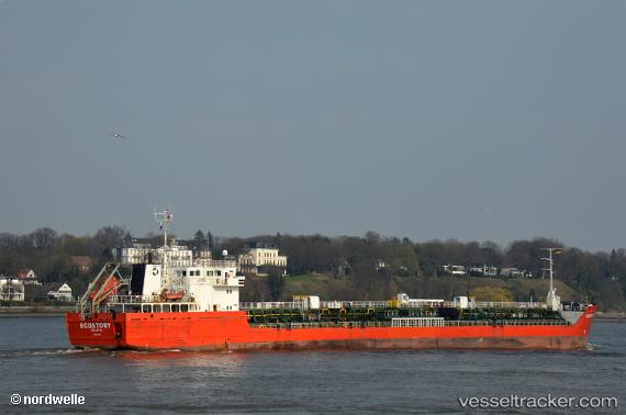
Vessel ECOSTORY IMO: 9175212, MMSI: 241713000 Oil Products Tanker

callsign: SVDH8
size: 130x17

Live AIS position: UTC. Near Eleusina), updated 2023-02-03 11:38:16 UTC.

Find the position of the vessel ECOSTORY on the map. The latter are known coordinates and path.

marine traffic ship tracker show on live map

The current position of vessel ECOSTORY is 38.02830 lat / 23.52724 lng. Updated: 2023-02-03 11:38:16 UTC

Currently sailing under the flag of Greece

ECOSTORY built in 2002 year

Deadweight:
6623 t

Details:


Last coordinates of the vessel:
2023-02-03 11:38:16 UTC, 38.02830, 23.52724, course: 175.8, speed: 0.1

Track of the vessel in the last 28 days


Most frequent ports a vessels calls at ECOSTORY (241713000):

Skaramangas, traffic: 9
Salamis, traffic: 8
Piraeus, traffic: 2
Algeciras, traffic: 1

Link to the map:


Find another ship

ECOSTORY (241713000) last ports (portcalls and passsages)

Skaramangas | 2023-02-17 02:44:03
Salamis | 2023-02-15 20:46:06
Skaramangas | 2023-02-12 23:57:03
Salamis | 2023-02-11 18:09:11
Skaramangas | 2023-02-08 21:14:20
Salamis | 2023-02-07 15:08:13
Skaramangas | 2023-02-04 18:06:02
Salamis | 2023-02-03 12:08:52
Skaramangas | 2023-01-31 17:35:09
Salamis | 2023-01-30 11:31:19
Skaramangas | 2023-01-27 15:09:29
Salamis | 2023-01-26 09:11:11
Skaramangas | 2023-01-23 15:01:23
Salamis | 2023-01-22 09:08:58
Skaramangas | 2023-01-19 11:30:25
Salamis | 2023-01-17 00:00:37
Skaramangas | 2023-01-15 08:49:35
Algeciras | 2023-01-03 08:30:29