 vesseltracker.com
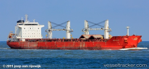
Vessel ENDEAVOR IMO: 9330642, MMSI: 636020854 Bulk Carrier
UTC, 0.62600, 79.76820, course: 77, speed: 9.8
UTC, 0.80425, 80.42267, course: 77, speed: 9.5
2026-03-24 17:40:04 UTC, 0.88248, 80.67655, course: 78, speed: 9.9
Live Vessel ENDEAVOR Analytics (details, animations, etc.)
Live AIS position: UTC. 303 nm S of Matara), updated 2026-03-24 17:40:04 UTC.Find the position of the vessel ENDEAVOR on the map. The latter are known coordinates and path.
marine traffic ship tracker show on live map
The current position of vessel ENDEAVOR is 0.88248 lat / 80.67655 lng. Updated: 2026-03-24 17:40:04 UTCCurrently sailing under the flag of Liberia
ENDEAVOR built in 2008 year
Deadweight:
53496 tDetails:
Last coordinates of the vessel:
UTC, 0.47607, 79.18539, course: 81, speed: 9.8UTC, 0.62600, 79.76820, course: 77, speed: 9.8
UTC, 0.80425, 80.42267, course: 77, speed: 9.5
2026-03-24 17:40:04 UTC, 0.88248, 80.67655, course: 78, speed: 9.9