 vesseltracker.com
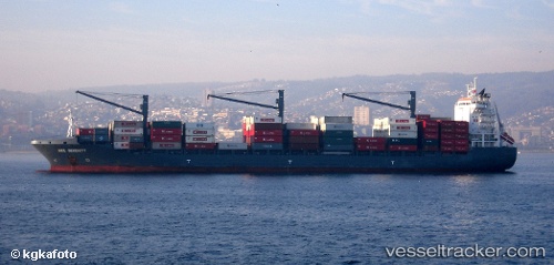
MSC Palantium III
Current StatusLive Vessel MSC Palantium III Analytics (details, animations, etc.)
Where is the vessel?
MSC Palantium III is currently in Near Semarang, based on AIS data received about 2h ago.
Latest AIS update:
Current position: 6.84035° S, 110.40377° E (Near Semarang)
Vessel profile: MSC Palantium III is a Container Ship with dimensions 30m x 209m.
This page combines live AIS, route history, probable destination signals, nearby traffic, and port activity for practical vessel monitoring.
The current position of vessel MSC Palantium III is -6.84035 lat / 110.40377 lng. Updated: 2026-03-25 05:20:57 UTCNearest reference points:
- Near Batang
- 26 nm N of Pemalang
- 49 nm NE of TANJUNG JATI
Currently sailing under the flag of Liberia
MSC Palantium III built in 2006 year
Deadweight:
34304 tDetails:
Recent AIS points (UTC):
2026-03-25 00:11:57 UTC · -6.83768, 110.40442 · SOG 0 kn · COG 245°2026-03-25 02:05:57 UTC · -6.83837, 110.40458 · SOG 0 kn · COG 258°
2026-03-25 04:02:55 UTC · -6.84023, 110.40396 · SOG 0 kn · COG 328°
2026-03-25 05:20:57 UTC · -6.84035, 110.40377 · SOG 0 kn · COG 333°