 vesseltracker.com
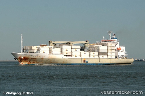
 STAR PRIMA
Current Status
Where is the vessel?
STAR PRIMA is currently in 11 nm E of Anse du Mai, based on AIS data received about 2h ago.
Latest AIS update:
Current position: 15.61442° N, 61.18943° W (11 nm E of Anse du Mai)
Average speed (last 7 days): Loading…
Average speed (last 30 days): Loading…
Vessel profile: STAR PRIMA is a Refrigerated Cargo Ship with dimensions 162m x 163m.
This page combines live AIS, route history, probable destination signals, nearby traffic, and port activity for practical vessel monitoring.
The current position of vessel STAR PRIMA is 15.61442 lat / -61.18943 lng. Updated: 2026-03-25 09:48:56 UTCNearest reference points:
- Near Le Gosier
- Near Pointe A Pitre
- Near Fort De France
Currently sailing under the flag of Bahamas ![]()
STAR PRIMA built in 2006 year
Deadweight:
13189 tDetails:
Live Vessel STAR PRIMA Analytics (details, animations, etc.)
Recent AIS points (UTC):
2026-03-25 03:55:23 UTC · 14.29875, -60.51118 · SOG 14.8 kn · COG 343°2026-03-25 06:05:45 UTC · 14.80410, -60.73309 · SOG 15.5 kn · COG 333°
2026-03-25 07:41:21 UTC · 15.16021, -60.93162 · SOG 15 kn · COG 329°
2026-03-25 09:48:56 UTC · 15.61442, -61.18943 · SOG 14 kn · COG 334°