 vesseltracker.com
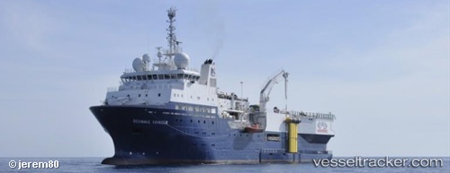
Vessel Eagle Explorer IMO: 9381299, MMSI: 209414000 Research Vessel
UTC, 27.40242, -94.32291, course: 190, speed: 3
UTC, 27.31523, -94.32165, course: 185, speed: 3.3
2026-03-21 17:22:12 UTC, 27.24103, -94.32087, course: 186, speed: 3
Live Vessel Eagle Explorer Analytics (details, animations, etc.)
Live AIS position: UTC. 113 nm SE of Quintana), updated 2026-03-21 17:22:12 UTC.Find the position of the vessel Eagle Explorer on the map. The latter are known coordinates and path.
marine traffic ship tracker show on live map
The current position of vessel Eagle Explorer is 27.24103 lat / -94.32087 lng. Updated: 2026-03-21 17:22:12 UTCCurrently sailing under the flag of Cyprus
Details:
Last coordinates of the vessel:
UTC, 27.51689, -94.32403, course: 186, speed: 3.9UTC, 27.40242, -94.32291, course: 190, speed: 3
UTC, 27.31523, -94.32165, course: 185, speed: 3.3
2026-03-21 17:22:12 UTC, 27.24103, -94.32087, course: 186, speed: 3