 vesseltracker.com
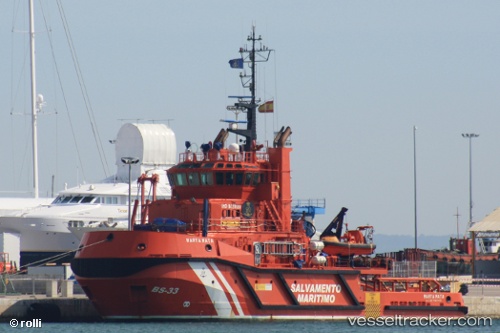
 Marta Mata
Current Status
Where is the vessel?
Marta Mata is currently in Near PALMA DE MALLORCA, based on AIS data received about 3h ago.
Latest AIS update:
Current position: 39.56332° N, 2.63513° E (Near PALMA DE MALLORCA)
Average speed (last 7 days): Loading…
Average speed (last 30 days): Loading…
Vessel profile: Marta Mata is a Tug with dimensions 39m x 12m.
This page combines live AIS, route history, probable destination signals, nearby traffic, and port activity for practical vessel monitoring.
The current position of vessel Marta Mata is 39.56332 lat / 2.63513 lng. Updated: 2026-03-25 15:51:04 UTCNearest reference points:
- Near PALMA DE MALLORCA
- Near Palma
- Near PORTALS NOUS
Currently sailing under the flag of Spain ![]()
Marta Mata built in 2008 year
Deadweight:
550 tDetails:
Live Vessel Marta Mata Analytics (details, animations, etc.)
Recent AIS points (UTC):
2026-03-25 09:26:38 UTC · 39.56321, 2.63512 · SOG 0 kn · COG 330°2026-03-25 11:45:04 UTC · 39.56329, 2.63509 · SOG 0 kn · COG 330°
2026-03-25 14:17:15 UTC · 39.56330, 2.63515 · SOG 0 kn · COG 330°
2026-03-25 15:51:04 UTC · 39.56332, 2.63513 · SOG 0 kn · COG 330°