.
Vessel photo of Jose Maria Espana (IMO 9429962) vesseltracker.com

Jose Maria Espana

Vessel type: Multi Purpose Carrier | IMO: 9429962 | MMSI: MMSI: 356441000
Call sign: H3WB | Dimensions: 22 m x 655 m
Current Status

Where is the vessel?

Jose Maria Espana is currently in 32 nm S of Stilbaai, based on AIS data received less than 1h ago.

Latest AIS update:

Current position: 34.86816° S, 21.65132° E (32 nm S of Stilbaai)

Average speed (last 7 days): Loading…

Average speed (last 30 days): Loading…

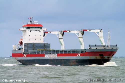
Vessel profile: Jose Maria Espana is a Multi Purpose Carrier with dimensions 22m x 655m.

This page combines live AIS, route history, probable destination signals, nearby traffic, and port activity for practical vessel monitoring.

The current position of vessel Jose Maria Espana is -34.86816 lat / 21.65132 lng. Updated: 2026-04-08 13:57:36 UTC
Nearest reference points:
  • 37 nm S of Mosselbaai
  • 16 nm S of Mosselbaai
  • Near Mosselbaai
Details:

Live Vessel Jose Maria Espana Analytics (details, animations, etc.)


Recent AIS points (UTC):
2026-04-08 08:14:16 UTC · -34.72819, 22.75904 · SOG 9.5 kn · COG 265°
2026-04-08 10:14:16 UTC · -34.76868, 22.37689 · SOG 9.6 kn · COG 263°
2026-04-08 12:21:05 UTC · -34.81402, 21.96375 · SOG 9.7 kn · COG 257°
2026-04-08 13:57:36 UTC · -34.86816, 21.65132 · SOG 9.8 kn · COG 256°

Track of the vessel in the last 60 days


UTC: --
Start: -- Track timeline (UTC) End: --
Encountered: --


Link to the map:


Find another ship

Jose_Maria_Espana (356441000) last ports (portcalls and passsages)

BUKOM ISLAND | 2025-06-05 21:32:51
PULAU SAMBU | 2025-06-05 20:52:27
TANAH MERAH | 2025-06-05 06:41:16
PENGERANG | 2025-06-05 06:00:38
Taboneo | 2025-06-01 01:13:51
Taboneo | 2025-05-28 00:48:11
Fangcheng | 2025-05-17 14:17:40
PENGERANG | 2025-05-11 02:57:25
TANAH MERAH | 2025-05-11 02:11:17
PULAU SAMBU | 2025-05-11 00:57:12
SALDANHA | 2025-04-15 01:56:41
Saldanha Bay | 2025-04-15 00:35:16
Saldanha Bay | 2025-04-09 21:39:36
PULAU SAMBU | 2025-03-11 20:59:24
TANAH MERAH | 2025-03-10 19:49:09
PENGERANG | 2025-03-10 18:57:48
Taboneo | 2025-03-05 06:03:06
Taboneo | 2025-03-01 05:59:30
Taboneo | 2025-02-25 05:27:31
Rizhao | 2025-02-12 22:09:44
TANAH MERAH | 2025-01-24 21:18:25
PULAU SAMBU | 2025-01-24 19:57:34
SALDANHA | 2024-12-27 10:36:28
Saldanha Bay | 2024-12-27 09:01:54
PULAU SAMBU | 2024-11-16 23:49:55
TANAH MERAH | 2024-11-16 07:32:25
PENGERANG | 2024-11-16 06:26:36
Taboneo | 2024-11-11 04:19:23
Taboneo | 2024-11-07 03:55:24
Taboneo | 2024-11-03 03:06:14
Rizhao | 2024-10-20 11:44:05
Singapore | 2024-10-06 01:22:15
Ponta da Madeira | 2024-08-19 21:51:34
Singapore | 2024-06-26 23:07:16
Jingjiang | 2024-05-31 10:41:03
La Guaira | 2024-05-23 00:42:28
Jingjiang | 2024-05-13 03:05:27
Selat Lombok | 2024-04-24 00:42:26
Samson Point | 2024-04-19 00:44:12
Selat Lombok | 2024-04-09 18:57:39
Sambu | 2024-03-11 22:47:47
Singapore | 2023-11-24 03:05:35
Sambu | 2023-11-24 02:24:01
Singapore | 2023-09-24 09:28:48
Sambu | 2023-09-24 08:34:57
Saldanha Bay | 2023-08-23 05:57:11
Saldanha Bay | 2023-08-17 11:11:56
Singapore | 2023-07-13 13:03:19
Taicang | 2023-06-24 00:29:06
Wusong | 2023-06-23 07:22:12
Singapore | 2023-06-10 22:53:54
Saldanha Bay | 2023-05-09 16:32:23
Cape Of Good Hope | 2023-05-09 08:31:55
Vishakhapatnam | 2023-04-13 23:19:05
Richards Bay | 2023-03-22 05:14:41
Singapore | 2023-02-22 08:41:17
Sambu | 2023-01-12 20:08:04
Saldanha Bay | 2022-12-16 11:50:21
Singapore | 2022-09-20 22:09:01
Port Louis | 2022-09-04 07:16:08
Sitrah Anchorage | 2022-06-17 19:28:50
Sitrah Anchorage | 2022-04-01 00:10:23
Ra’S Shukhayr | 2021-12-29 02:43:42
Ras Gharib | 2021-12-29 01:26:14
Ayn Sukhnah | 2021-12-28 19:47:43
Bur Ibrahim | 2021-12-28 17:35:42
Port Said | 2021-12-28 07:40:04
Algeciras | 2021-12-20 16:25:01
Strait Of Gibraltar | 2021-12-18 12:19:05
Annapolis | 2021-12-05 00:21:32
Baltimore | 2021-12-03 04:23:59