 vesseltracker.com
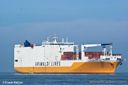
Vessel Grande Congo IMO: 9437921, MMSI: 247302700 Ro Ro Cargo Ship
UTC, 26.01167, -39.34833, course: -1, speed: 15
UTC, 26.00500, -40.00167, course: -1, speed: 14
2026-02-09 22:39:22 UTC, 26.01140, -40.23949, course: 269, speed: 14.5
Live AIS position:
UTC. 226 nm N of Efpalion),
updated 2026-02-09 22:39:22 UTC.
Find the position of the vessel Grande Congo on the map. The latter are known coordinates and path.
marine traffic ship tracker show on live map
The current position of vessel Grande Congo is 26.01140 lat / -40.23949 lng. Updated: 2026-02-09 22:39:22 UTCCurrently sailing under the flag of Italy
Grande Congo built in 2010 year
Deadweight:
25682 tDetails:
Last coordinates of the vessel:
UTC, 26.02833, -38.74167, course: -1, speed: 15UTC, 26.01167, -39.34833, course: -1, speed: 15
UTC, 26.00500, -40.00167, course: -1, speed: 14
2026-02-09 22:39:22 UTC, 26.01140, -40.23949, course: 269, speed: 14.5