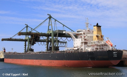
vessel Amity IMO: 9492103, Bulk Carrier
vesseltracker.com
Vessel Amity IMO: 9492103, Bulk Carrier
MMSI: 356558000 callsign: 3FAI3 size: 295x46

Find the position of the vessel Amity on the map. The latter are known coordinates and path.

marine traffic ship tracker show on live map

The current position of vessel Amity is 31.33819 lat / 122.96591 lng. Updated: 2023-08-29 00:34:28 UTC

Currently sailing under the flag of Panama

Amity built in 2009 year

Deadweight:
180311 t

Details:


Last coordinates of the vessel:
2023-08-29 00:34:28 UTC, 31.33819, 122.96591, course: -1, speed: 10.6

Track of the vessel in the last 14 days


Most frequent ports a vessels calls at Amity (356558000):

Sept Iles, traffic: 7
Dampier, traffic: 4
Sitrah Anchorage, traffic: 2
Port Said, traffic: 2
Port Talbot, traffic: 2
Selat Lombok, traffic: 2
Strait Of Gibraltar, traffic: 1
Algeciras, traffic: 1
Wu-Sung, traffic: 1
Ayn Sukhnah, traffic: 1
Wusong, traffic: 1
Come By Chance, traffic: 1
Yeosu, traffic: 1
Grand Banks South, traffic: 1
Yosu, traffic: 1

Link to the map:


Find another ship

Amity (356558000) last ports (portcalls and passsages)

Yosu | 2023-02-13 11:42:45
Port Said | 2023-01-04 08:45:11
Algeciras | 2022-12-27 02:02:12
Strait Of Gibraltar | 2022-12-26 08:48:24
Grand Banks South | 2022-12-18 14:19:11
Port Talbot | 2022-11-18 08:59:04
Port Talbot | 2022-11-13 20:04:32
Come By Chance | 2022-11-05 08:47:37
Sept Iles | 2022-11-02 17:07:03
Sept Iles | 2022-10-29 16:29:36
Sept Iles | 2022-10-25 13:28:51
Sept Iles | 2022-10-21 10:39:47
Sept Iles | 2022-10-17 08:04:44
Sept Iles | 2022-10-13 07:57:38
Sept Iles | 2022-10-09 07:10:10
Port Said | 2022-07-31 16:36:29
Ayn Sukhnah | 2022-07-30 01:51:37
Sitrah Anchorage | 2022-06-30 19:38:54
Sitrah Anchorage | 2022-06-26 19:36:07
Wusong | 2022-03-03 06:57:05
Dampier | 2022-02-06 23:59:04
Selat Lombok | 2021-12-26 21:45:08
Dampier | 2021-12-22 06:25:36
Samson Point | 2021-09-30 16:11:59