 vesseltracker.com
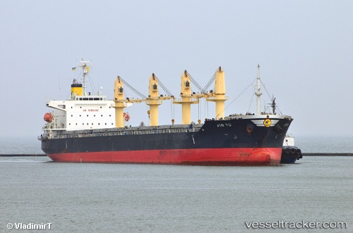
Vessel Ken Yo IMO: 9547154, MMSI: 353579000 Bulk Carrier
UTC, 13.58794, 119.59827, course: -1, speed: 12
UTC, 13.92860, 119.36670, course: -1, speed: 12.1
2026-03-25 00:00:14 UTC, 14.26229, 119.13832, course: -1, speed: 12.6
Live Vessel Ken Yo Analytics (details, animations, etc.)
Live AIS position: UTC. 67 nm SW of Subic Bay), updated 2026-03-25 00:00:14 UTC.Find the position of the vessel Ken Yo on the map. The latter are known coordinates and path.
marine traffic ship tracker show on live map
The current position of vessel Ken Yo is 14.26229 lat / 119.13832 lng. Updated: 2026-03-25 00:00:14 UTCCurrently sailing under the flag of Panama
Ken Yo built in 2012 year
Deadweight:
38462 tDetails:
Last coordinates of the vessel:
UTC, 13.25553, 119.83500, course: -1, speed: 11.9UTC, 13.58794, 119.59827, course: -1, speed: 12
UTC, 13.92860, 119.36670, course: -1, speed: 12.1
2026-03-25 00:00:14 UTC, 14.26229, 119.13832, course: -1, speed: 12.6