 Clearocean Maria
Current Status
Where is the vessel?
Clearocean Maria is currently in 72 nm W of Noank, based on AIS data received about 15h ago.
Latest AIS update:
Current position: 40.96708° N, 53.85066° W (72 nm W of Noank)
Average speed (last 7 days): Loading…
Average speed (last 30 days): Loading…
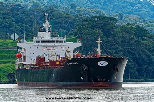
Vessel profile: Clearocean Maria is a Chemical Oil Products Tanker with dimensions 183m x 32m.
This page combines live AIS, route history, probable destination signals, nearby traffic, and port activity for practical vessel monitoring.
The current position of vessel Clearocean Maria is 40.96708 lat / -53.85066 lng. Updated: 2026-05-20 17:26:48 UTCNearest reference points:
- 28 nm NE of Valencia de San Juan
- 44 nm SE of Jonesville
- 63 nm SE of Azuara
Currently sailing under the flag of Liberia ![]()
Details:
Live Vessel Clearocean Maria Analytics (details, animations, etc.)
Recent AIS points (UTC):
2026-05-20 13:43:11 UTC · 40.93416, -52.98458 · SOG 10.7 kn · COG 277°2026-05-20 15:42:10 UTC · 40.96636, -53.44958 · SOG 10.5 kn · COG 283°
2026-05-20 16:24:37 UTC · 40.97756, -53.61425 · SOG 10.3 kn · COG 276°
2026-05-20 17:26:48 UTC · 40.96708, -53.85066 · SOG 10.6 kn · COG 270°