 vesseltracker.com
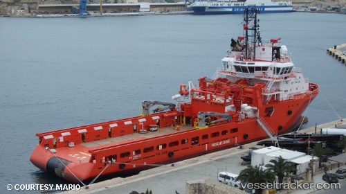
Vessel A. H. VARAZZE IMO: 9665566, MMSI: 710033420 Offshore Tug/Supply Ship
UTC, -22.45894, -40.10330, course: 31, speed: 2.9
UTC, -22.43433, -40.06420, course: 42, speed: 0.6
2026-03-24 14:13:22 UTC, -22.43423, -40.06433, course: 37, speed: 1
Live Vessel A. H. VARAZZE Analytics (details, animations, etc.)
Live AIS position: UTC. 23 nm NE of Fluminense FPSO), updated 2026-03-24 14:13:22 UTC.Find the position of the vessel A. H. VARAZZE on the map. The latter are known coordinates and path.
marine traffic ship tracker show on live map
The current position of vessel A. H. VARAZZE is -22.43423 lat / -40.06433 lng. Updated: 2026-03-24 14:13:22 UTCCurrently sailing under the flag of Brazil
A. H. VARAZZE built in 2014 year
Deadweight:
2874 tDetails:
Last coordinates of the vessel:
UTC, -22.41945, -40.07350, course: 29, speed: 0.8UTC, -22.45894, -40.10330, course: 31, speed: 2.9
UTC, -22.43433, -40.06420, course: 42, speed: 0.6
2026-03-24 14:13:22 UTC, -22.43423, -40.06433, course: 37, speed: 1