 vesseltracker.com
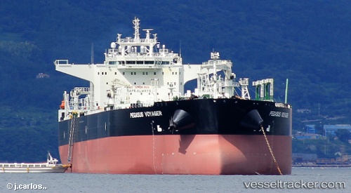
 Polaris Voyager
Current Status
Where is the vessel?
Polaris Voyager is currently in 175 nm S of Puerto Ángel, based on AIS data received about 2h ago.
Latest AIS update:
Current position: 12.87667° N, 97.32667° W (175 nm S of Puerto Ángel)
Average speed (last 7 days): Loading…
Average speed (last 30 days): Loading…
Vessel profile: Polaris Voyager is a Crude Oil Tanker with dimensions 276m x 48m.
This page combines live AIS, route history, probable destination signals, nearby traffic, and port activity for practical vessel monitoring.
The current position of vessel Polaris Voyager is 12.87667 lat / -97.32667 lng. Updated: 2026-03-25 17:52:44 UTCCurrently sailing under the flag of Bahamas ![]()
Details:
Live Vessel Polaris Voyager Analytics (details, animations, etc.)
Recent AIS points (UTC):
2026-03-25 12:14:44 UTC · 13.30289, -98.09577 · SOG 9.6 kn · COG 131°2026-03-25 13:25:40 UTC · 13.18835, -97.94079 · SOG 9.5 kn · COG 128°
2026-03-25 16:13:37 UTC · 12.95500, -97.56500 · SOG 9 kn · COG -1°
2026-03-25 17:52:44 UTC · 12.87667, -97.32667 · SOG 9 kn · COG -1°