 vesseltracker.com
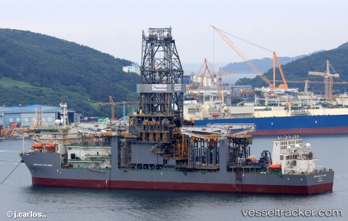
Vessel Deepwater Thalassa IMO: 9675169, MMSI: 538005123 Drilling Ship
UTC, 24.99575, -86.98926, course: -1, speed: 0
UTC, 24.99500, -86.98833, course: -1, speed: 0
2026-03-02 13:27:14 UTC, 24.99559, -86.98950, course: -1, speed: 0
Live AIS position:
UTC. 212 nm NE of Munshiganj),
updated 2026-03-02 13:27:14 UTC.
Find the position of the vessel Deepwater Thalassa on the map. The latter are known coordinates and path.
marine traffic ship tracker show on live map
The current position of vessel Deepwater Thalassa is 24.99559 lat / -86.98950 lng. Updated: 2026-03-02 13:27:14 UTCCurrently sailing under the flag of Marshall Is
Details:
Last coordinates of the vessel:
UTC, 24.99500, -86.98833, course: -1, speed: 0UTC, 24.99575, -86.98926, course: -1, speed: 0
UTC, 24.99500, -86.98833, course: -1, speed: 0
2026-03-02 13:27:14 UTC, 24.99559, -86.98950, course: -1, speed: 0