 vesseltracker.com
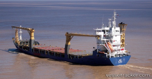
Vessel LARA IMO: 9221475, MMSI: 341501001 General Cargo
UTC, 40.95338, 28.86528, course: 241, speed: 0
UTC, 40.95349, 28.86521, course: 236, speed: 0
2026-02-23 21:37:17 UTC, 40.95368, 28.86518, course: 233, speed: 0
Live AIS position:
UTC. Near BAKIRKOY),
updated 2026-02-23 21:37:17 UTC.
Find the position of the vessel LARA on the map. The latter are known coordinates and path.
marine traffic ship tracker show on live map
The current position of vessel LARA is 40.95368 lat / 28.86518 lng. Updated: 2026-02-23 21:37:17 UTCCurrently sailing under the flag of Saint Kitts and Nevis
Details:
Last coordinates of the vessel:
UTC, 40.95336, 28.86529, course: 240, speed: 0UTC, 40.95338, 28.86528, course: 241, speed: 0
UTC, 40.95349, 28.86521, course: 236, speed: 0
2026-02-23 21:37:17 UTC, 40.95368, 28.86518, course: 233, speed: 0