.
vessel Caribbean Highway IMO: 9243473, Vehicles Carrier
vesseltracker.com
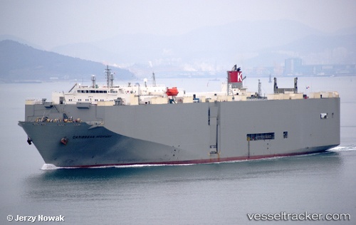
Vessel Caribbean Highway IMO: 9243473, MMSI: 352218000 Vehicles Carrier

callsign: H9ZW
size: 184x32

Live Vessel Caribbean Highway Analytics (details, animations, etc.)

Live AIS position: UTC. 14 nm NE of JINHAI HEAVY INDUSTR), updated 2026-03-04 20:16:52 UTC.

Find the position of the vessel Caribbean Highway on the map. The latter are known coordinates and path.

marine traffic ship tracker show on live map

The current position of vessel Caribbean Highway is 30.42650 lat / 122.44528 lng. Updated: 2026-03-04 20:16:52 UTC

Currently sailing under the flag of Panama

Caribbean Highway built in 2002 year

Deadweight:
17866 t

Details:


Last coordinates of the vessel:
UTC, 30.42656, 122.44532, course: 167, speed: 0
UTC, 30.42649, 122.44530, course: 167, speed: 0
UTC, 30.42642, 122.44526, course: 167, speed: 0
2026-03-04 20:16:52 UTC, 30.42650, 122.44528, course: 167, speed: 0

Track of the vessel in the last 28 days


Most frequent ports a vessels calls at Caribbean Highway (352218000):

Sambu, traffic: 9
Singapore, traffic: 7
Sao Luiz, traffic: 4
TANAH MERAH, traffic: 4
JURONG ISLAND, traffic: 4
BUKOM ISLAND, traffic: 3
PULAU SAMBU, traffic: 3
Taku Bar, traffic: 3
PENGERANG, traffic: 3
Lianyungang, traffic: 3
BAKAUHENI, traffic: 2
Ponta da Madeira, traffic: 2
Mokpo, traffic: 1
LANSHAN, traffic: 1
Port Des Galets, traffic: 1

Link to the map:


Find another ship

Caribbean_Highway (352218000) last ports (portcalls and passsages)

JURONG ISLAND | 2025-08-27 15:44:40
BUKOM ISLAND | 2025-08-27 14:53:13
PULAU SAMBU | 2025-08-26 16:22:19
TANAH MERAH | 2025-08-26 15:37:53
PENGERANG | 2025-08-26 14:51:02
DONGJIAKOU | 2025-08-15 12:32:46
BAKAUHENI | 2025-07-31 16:08:40
JURONG ISLAND | 2025-05-29 00:30:30
BUKOM ISLAND | 2025-05-28 23:40:31
PULAU SAMBU | 2025-05-28 23:01:33
TANAH MERAH | 2025-05-27 22:20:30
PENGERANG | 2025-05-27 21:01:37
JURONG ISLAND | 2025-02-24 16:23:39
PULAU SAMBU | 2025-02-24 15:35:26
TANAH MERAH | 2025-02-23 15:24:08
PENGERANG | 2025-02-23 13:12:28
SURALAYA | 2025-02-07 12:34:47
BAKAUHENI | 2025-02-07 11:11:49
BATU AMPAR | 2024-12-07 08:46:10
TANAH MERAH | 2024-12-05 05:13:46
LANSHAN | 2024-11-25 05:26:47
Taku Bar | 2024-11-22 21:25:47
Dagu Bar | 2024-11-19 20:16:12
Singapore | 2024-08-24 10:10:20
Lianyungang | 2024-05-03 18:34:54
Brixham | 2024-02-27 06:08:33
Ponta da Madeira | 2024-02-01 00:24:56
Sao Luiz | 2024-01-31 23:38:49
Singapore | 2023-12-21 23:21:17
Lianyungang | 2023-12-10 04:58:28
Lianyungang | 2023-12-06 03:48:18
Ponta da Madeira | 2023-10-14 05:33:34
Sao Luiz | 2023-10-14 03:27:26
Tubarao | 2023-07-15 09:33:11
Sambu | 2023-06-09 19:19:31
Taku Bar | 2023-02-07 17:34:44
Taku Bar | 2023-02-03 17:07:24
Sao Luiz | 2022-12-10 05:48:42
Singapore | 2022-11-02 23:26:30
Port Des Galets | 2022-09-27 19:35:53
Sao Luiz | 2022-09-04 10:32:29
Singapore | 2022-08-01 01:04:08
Mokpo | 2022-03-29 15:15:33