 vesseltracker.com
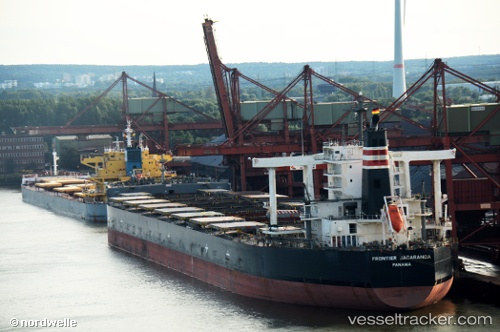
Vessel FRONTIER JACARANDA IMO: 9552393, MMSI: 431122000 Bulk Carrier
UTC, -0.16860, 86.97220, course: 51, speed: 12.4
UTC, 0.14851, 87.37313, course: 51, speed: 12.3
2026-03-04 21:51:04 UTC, 0.36333, 87.63667, course: -1, speed: 12
Live Vessel FRONTIER JACARANDA Analytics (details, animations, etc.)
Live AIS position: UTC. 372 nm S of Abakaliki), updated 2026-03-04 21:51:04 UTC.Find the position of the vessel FRONTIER JACARANDA on the map. The latter are known coordinates and path.
marine traffic ship tracker show on live map
The current position of vessel FRONTIER JACARANDA is 0.36333 lat / 87.63667 lng. Updated: 2026-03-04 21:51:04 UTCCurrently sailing under the flag of Japan
FRONTIER JACARANDA built in 2011 year
Deadweight:
182757 tDetails:
Last coordinates of the vessel:
UTC, -0.16860, 86.97220, course: 51, speed: 12.4UTC, -0.16860, 86.97220, course: 51, speed: 12.4
UTC, 0.14851, 87.37313, course: 51, speed: 12.3
2026-03-04 21:51:04 UTC, 0.36333, 87.63667, course: -1, speed: 12