 vesseltracker.com
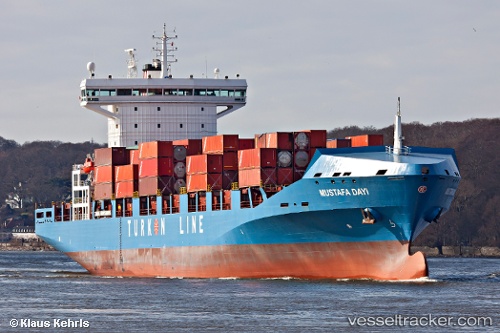
Vessel Mustafa Dayi IMO: 9365855, MMSI: 271042433 Container Ship
UTC, 36.79957, 34.64073, course: 35, speed: 0
UTC, 36.79958, 34.64072, course: 35, speed: 0
2026-02-22 06:23:43 UTC, 36.51686, 34.63757, course: 219, speed: 11.2
Live AIS position:
UTC. 16 nm S of Mersin),
updated 2026-02-22 06:23:43 UTC.
Find the position of the vessel Mustafa Dayi on the map. The latter are known coordinates and path.
marine traffic ship tracker show on live map
The current position of vessel Mustafa Dayi is 36.51686 lat / 34.63757 lng. Updated: 2026-02-22 06:23:43 UTCCurrently sailing under the flag of Turkey
Mustafa Dayi built in 2011 year
Deadweight:
26811 tDetails:
Last coordinates of the vessel:
UTC, 36.79960, 34.64071, course: 35, speed: 0UTC, 36.79957, 34.64073, course: 35, speed: 0
UTC, 36.79958, 34.64072, course: 35, speed: 0
2026-02-22 06:23:43 UTC, 36.51686, 34.63757, course: 219, speed: 11.2