 vesseltracker.com
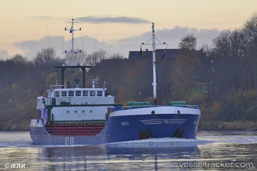
Vessel PAULIN B IMO: 9120102, MMSI: 211839040 General Cargo Ship
UTC, 52.55501, 1.75174, course: -1, speed: 0
UTC, 52.55665, 1.75166, course: -1, speed: 0
2026-03-02 23:23:52 UTC, 52.55707, 1.75175, course: 179, speed: 0.1
Live AIS position:
UTC. Near Gorleston-on-Sea),
updated 2026-03-02 23:23:52 UTC.
Find the position of the vessel PAULIN B on the map. The latter are known coordinates and path.
marine traffic ship tracker show on live map
The current position of vessel PAULIN B is 52.55707 lat / 1.75175 lng. Updated: 2026-03-02 23:23:52 UTCCurrently sailing under the flag of Germany
PAULIN B built in 1995 year
Deadweight:
2335 tDetails:
Last coordinates of the vessel:
UTC, 52.55500, 1.75167, course: -1, speed: 0UTC, 52.55501, 1.75174, course: -1, speed: 0
UTC, 52.55665, 1.75166, course: -1, speed: 0
2026-03-02 23:23:52 UTC, 52.55707, 1.75175, course: 179, speed: 0.1