 vesseltracker.com
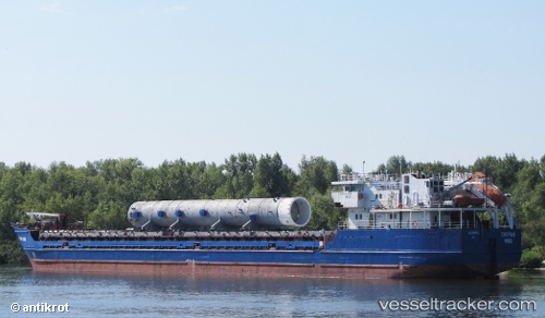
Vessel Habibe Ana IMO: 9133355, MMSI: 372098000 General Cargo Ship
UTC, 42.15557, 41.65869, course: 94, speed: 0
UTC, 42.15561, 41.65867, course: 94, speed: 0
2026-01-23 22:16:31 UTC, 42.15560, 41.65872, course: 93, speed: 0
Live AIS position:
UTC. Near Poti),
updated 2026-01-23 22:16:31 UTC.
Find the position of the vessel Habibe Ana on the map. The latter are known coordinates and path.
marine traffic ship tracker show on live map
The current position of vessel Habibe Ana is 42.15560 lat / 41.65872 lng. Updated: 2026-01-23 22:16:31 UTCCurrently sailing under the flag of Panama
Habibe Ana built in 1995 year
Deadweight:
3837 tDetails:
Last coordinates of the vessel:
UTC, 42.15558, 41.65873, course: 93, speed: 0UTC, 42.15557, 41.65869, course: 94, speed: 0
UTC, 42.15561, 41.65867, course: 94, speed: 0
2026-01-23 22:16:31 UTC, 42.15560, 41.65872, course: 93, speed: 0