 vesseltracker.com
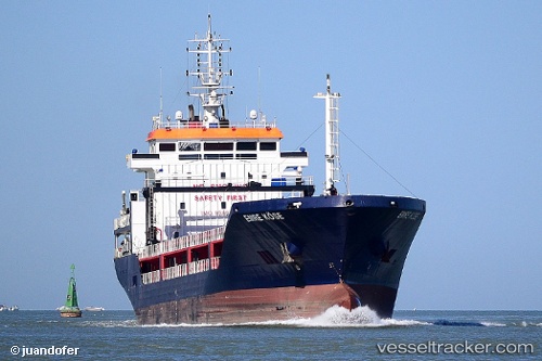
Vessel GUNERLER IMO: 9598684, MMSI: 314686000 General Cargo Ship
UTC, 37.26989, 9.95050, course: 324, speed: 0.3
UTC, 37.27032, 9.95015, course: 318, speed: 0.4
2026-02-17 18:20:23 UTC, 37.27037, 9.94998, course: 328, speed: 0.4
Live AIS position:
UTC. Near BIZERTE),
updated 2026-02-17 18:20:23 UTC.
Find the position of the vessel GUNERLER on the map. The latter are known coordinates and path.
marine traffic ship tracker show on live map
The current position of vessel GUNERLER is 37.27037 lat / 9.94998 lng. Updated: 2026-02-17 18:20:23 UTCCurrently sailing under the flag of Barbados
GUNERLER built in 2011 year
Deadweight:
6603 tDetails:
Last coordinates of the vessel:
UTC, 37.26975, 9.94923, course: 281, speed: 0.8UTC, 37.26989, 9.95050, course: 324, speed: 0.3
UTC, 37.27032, 9.95015, course: 318, speed: 0.4
2026-02-17 18:20:23 UTC, 37.27037, 9.94998, course: 328, speed: 0.4