 vesseltracker.com
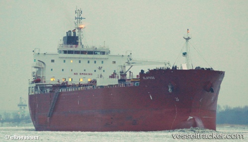
 VIRGEN DE LA AURORA
Current Status
Where is the vessel?
VIRGEN DE LA AURORA is currently in 75 nm SW of Gulfmex Lightering Area, based on AIS data received less than 1h ago.
Latest AIS update:
Current position: 26.64833° N, 91.49500° W (75 nm SW of Gulfmex Lightering Area)
Average speed (last 7 days): Loading…
Average speed (last 30 days): Loading…
Vessel profile: VIRGEN DE LA AURORA is a Chemical/Oil Products Tanker with dimensions 32m x 183m.
This page combines live AIS, route history, probable destination signals, nearby traffic, and port activity for practical vessel monitoring.
The current position of vessel VIRGEN DE LA AURORA is 26.64833 lat / -91.49500 lng. Updated: 2026-04-14 01:54:14 UTCNearest reference points:
- 94 nm S of Gulfmex Lightering Area
- 124 nm SW of Gulfmex Lightering Area
- 83 nm W of Gulfmex Lightering Area
Currently sailing under the flag of Cyprus ![]()
VIRGEN DE LA AURORA built in 2013 year
Deadweight:
49997 tDetails:
Live Vessel VIRGEN DE LA AURORA Analytics (details, animations, etc.)
Recent AIS points (UTC):
2026-04-13 19:38:06 UTC · 27.57955, -92.34703 · SOG 10.9 kn · COG 144°2026-04-13 21:18:20 UTC · 27.32833, -92.13667 · SOG 11 kn · COG -1°
2026-04-13 23:57:15 UTC · 26.91167, -91.79167 · SOG 11 kn · COG -1°
2026-04-14 01:54:14 UTC · 26.64833, -91.49500 · SOG 11 kn · COG -1°