 vesseltracker.com
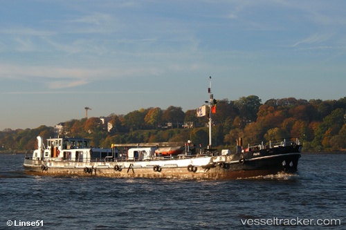
Vessel Kathi IMO: 7006974, MMSI: 211372620 Service Ship
UTC, 53.53816, 9.86938, course: 329, speed: 0
UTC, 53.53818, 9.86934, course: 332, speed: 0
2026-03-14 06:13:09 UTC, 53.53814, 9.86935, course: -1, speed: 0
Live Vessel Kathi Analytics (details, animations, etc.)
Live AIS position: UTC. Near Bahrenfeld), updated 2026-03-14 06:13:09 UTC.Find the position of the vessel Kathi on the map. The latter are known coordinates and path.
marine traffic ship tracker show on live map
The current position of vessel Kathi is 53.53814 lat / 9.86935 lng. Updated: 2026-03-14 06:13:09 UTCCurrently sailing under the flag of Germany
Kathi built in 1970 year
Deadweight:
297 tDetails:
Last coordinates of the vessel:
UTC, 53.53816, 9.86935, course: 332, speed: 0UTC, 53.53816, 9.86938, course: 329, speed: 0
UTC, 53.53818, 9.86934, course: 332, speed: 0
2026-03-14 06:13:09 UTC, 53.53814, 9.86935, course: -1, speed: 0