 vesseltracker.com
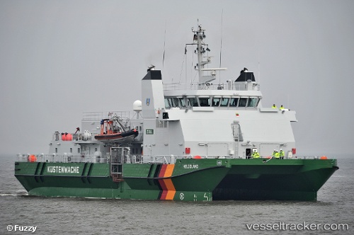
 Helgoland
Current Status
Where is the vessel?
Helgoland is currently in Near Cuxhaven, based on AIS data received less than 1h ago.
Latest AIS update:
Current position: 53.85954° N, 8.71462° E (Near Cuxhaven)
Average speed (last 7 days): Loading…
Average speed (last 30 days): Loading…
Vessel profile: Helgoland is a Patrol Vessel with dimensions 48m x 18m.
This page combines live AIS, route history, probable destination signals, nearby traffic, and port activity for practical vessel monitoring.
The current position of vessel Helgoland is 53.85954 lat / 8.71462 lng. Updated: 2026-04-23 04:39:26 UTCNearest reference points:
- Near BUESUM
- Near Bremerhaven
- Near Kiel Canal
Currently sailing under the flag of Germany ![]()
Helgoland built in 2009 year
Deadweight:
132 tDetails:
Live Vessel Helgoland Analytics (details, animations, etc.)
Recent AIS points (UTC):
2026-04-23 01:09:26 UTC · 53.85955, 8.71463 · SOG 0 kn · COG 310°2026-04-23 01:27:25 UTC · 53.85954, 8.71462 · SOG 0 kn · COG 310°
2026-04-23 03:27:26 UTC · 53.85954, 8.71463 · SOG 0 kn · COG 311°
2026-04-23 04:39:26 UTC · 53.85954, 8.71462 · SOG 0 kn · COG 310°