 vesseltracker.com
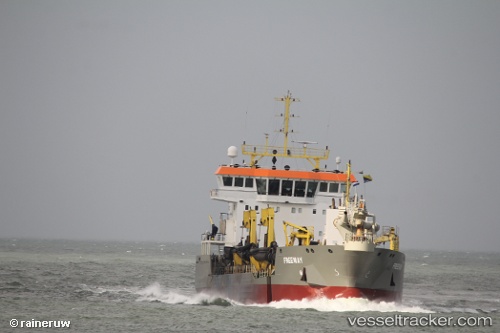
 Freeway
Current Status
Where is the vessel?
Freeway is currently in Near Aberdeen, based on AIS data received about 2h ago.
Latest AIS update:
Current position: 57.13420° N, 2.04010° W (Near Aberdeen)
Average speed (last 7 days): Loading…
Average speed (last 30 days): Loading…
Vessel profile: Freeway is a Hopper Dredger with dimensions 92m x 92m.
This page combines live AIS, route history, probable destination signals, nearby traffic, and port activity for practical vessel monitoring.
The current position of vessel Freeway is 57.13420 lat / -2.04010 lng. Updated: 2026-03-29 21:41:04 UTCNearest reference points:
- Near Aberdeen
- Near PETERHEAD
- Near Peterhead
Currently sailing under the flag of Cyprus ![]()
Details:
Live Vessel Freeway Analytics (details, animations, etc.)
Recent AIS points (UTC):
2026-03-29 15:41:44 UTC · 57.13331, -2.04298 · SOG 1.1 kn · COG 242°2026-03-29 17:23:44 UTC · 57.13391, -2.00838 · SOG 5.7 kn · COG 309°
2026-03-29 19:28:42 UTC · 57.14826, -2.05697 · SOG 1.3 kn · COG 238°
2026-03-29 21:41:04 UTC · 57.13420, -2.04010 · SOG 7.3 kn · COG 253°