 vesseltracker.com
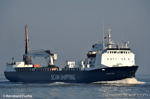
Vessel Karmsund IMO: 7724203, MMSI: 219023116 Palletized Cargo Ship
UTC, 66.81052, 13.94078, course: -1, speed: 0
UTC, 66.81052, 13.94078, course: -1, speed: 0
2026-03-02 22:55:14 UTC, 66.81052, 13.94078, course: -1, speed: 0
Live AIS position:
UTC. Near GLOMFJORD),
updated 2026-03-02 22:55:14 UTC.
Find the position of the vessel Karmsund on the map. The latter are known coordinates and path.
marine traffic ship tracker show on live map
The current position of vessel Karmsund is 66.81052 lat / 13.94078 lng. Updated: 2026-03-02 22:55:14 UTCCurrently sailing under the flag of Denmark
Karmsund built in 1979 year
Deadweight:
2020 tDetails:
Last coordinates of the vessel:
UTC, 66.81054, 13.94081, course: -1, speed: 0UTC, 66.81052, 13.94078, course: -1, speed: 0
UTC, 66.81052, 13.94078, course: -1, speed: 0
2026-03-02 22:55:14 UTC, 66.81052, 13.94078, course: -1, speed: 0