 vesseltracker.com
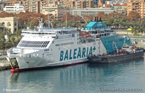
Vessel Martin I Soler IMO: 9390367, MMSI: 224637000 Passenger Ro Ro Cargo Ship
UTC, 41.34463, 2.17125, course: 189, speed: 0
UTC, 41.34464, 2.17128, course: 189, speed: 0
2026-03-08 05:29:53 UTC, 41.34462, 2.17130, course: 189, speed: 0
Live Vessel Martin I Soler Analytics (details, animations, etc.)
Live AIS position: UTC. Near Zona Franca de Barcelona), updated 2026-03-08 05:29:53 UTC.Find the position of the vessel Martin I Soler on the map. The latter are known coordinates and path.
marine traffic ship tracker show on live map
The current position of vessel Martin I Soler is 41.34462 lat / 2.17130 lng. Updated: 2026-03-08 05:29:53 UTCCurrently sailing under the flag of Spain
Martin I Soler built in 2008 year
Deadweight:
9737 tDetails:
Last coordinates of the vessel:
UTC, 41.34459, 2.17127, course: 189, speed: 0UTC, 41.34463, 2.17125, course: 189, speed: 0
UTC, 41.34464, 2.17128, course: 189, speed: 0
2026-03-08 05:29:53 UTC, 41.34462, 2.17130, course: 189, speed: 0