 vesseltracker.com
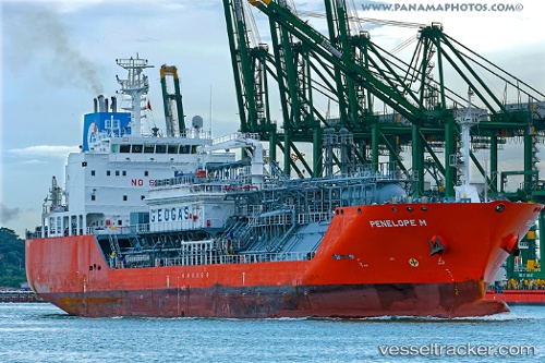
Penelope M
Current StatusWhere is the vessel?
Penelope M is currently in Near San Pedro De Macoris, based on AIS data received about 1d ago.
Latest AIS update:
Current position: 18.42027° N, 69.27989° W (Near San Pedro De Macoris)
Average speed (last 7 days): Loading…
Average speed (last 30 days): Loading…
Vessel profile: Penelope M is a Lpg Tanker with dimensions 20m x 120m.
This page combines live AIS, route history, probable destination signals, nearby traffic, and port activity for practical vessel monitoring.
The current position of vessel Penelope M is 18.42027 lat / -69.27989 lng. Updated: 2026-04-07 17:14:17 UTCNearest reference points:
- Near CASA DE CAMPO
- 32 nm N of Punta Cana Apt
- Near Bahia De Las Calderas
Details:
Live Vessel Penelope M Analytics (details, animations, etc.)
Recent AIS points (UTC):
2026-04-06 19:47:10 UTC · 18.40112, -70.02194 · SOG 0 kn · COG 130°2026-04-07 17:14:17 UTC · 18.42027, -69.27989 · SOG 0.4 kn · COG 155°
2026-04-07 17:14:17 UTC · 18.42027, -69.27989 · SOG 0.4 kn · COG 155°
2026-04-07 17:14:17 UTC · 18.42027, -69.27989 · SOG 0.4 kn · COG 155°