 vesseltracker.com
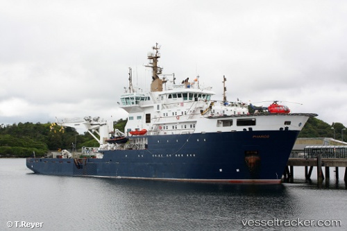
Vessel Pharos IMO: 9338606, MMSI: 233185000 Buoy Lighthouse Vessel
UTC, 55.94500, -4.73136, course: 114, speed: 0
UTC, 55.94501, -4.73136, course: 113, speed: 0
2026-03-25 02:26:43 UTC, 55.94500, -4.73136, course: 113, speed: 0
Live Vessel Pharos Analytics (details, animations, etc.)
Live AIS position: UTC. Near Greenock), updated 2026-03-25 02:26:43 UTC.Find the position of the vessel Pharos on the map. The latter are known coordinates and path.
marine traffic ship tracker show on live map
The current position of vessel Pharos is 55.94500 lat / -4.73136 lng. Updated: 2026-03-25 02:26:43 UTCCurrently sailing under the flag of United Kingdom
Pharos built in 2007 year
Deadweight:
1200 tDetails:
Last coordinates of the vessel:
UTC, 55.94500, -4.73136, course: 114, speed: 0UTC, 55.94500, -4.73136, course: 114, speed: 0
UTC, 55.94501, -4.73136, course: 113, speed: 0
2026-03-25 02:26:43 UTC, 55.94500, -4.73136, course: 113, speed: 0