 vesseltracker.com
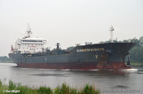
Vessel ELISABETH SCHULTE IMO: 9439840, MMSI: 235076265 Oil/Chemical Tanker
UTC, 55.95834, -4.86063, course: 47, speed: 9.7
UTC, 55.89277, -4.40388, course: 237, speed: 0.9
2026-01-31 11:20:37 UTC, 55.89223, -4.39700, course: 302, speed: 0
Live AIS position:
UTC. Near Clydebank),
updated 2026-01-31 11:20:37 UTC.
Find the position of the vessel ELISABETH SCHULTE on the map. The latter are known coordinates and path.
marine traffic ship tracker show on live map
The current position of vessel ELISABETH SCHULTE is 55.89223 lat / -4.39700 lng. Updated: 2026-01-31 11:20:37 UTCCurrently sailing under the flag of United Kingdom
ELISABETH SCHULTE built in 2010 year
Deadweight:
16371 tDetails:
Last coordinates of the vessel:
UTC, 55.65170, -4.91567, course: 314, speed: 10UTC, 55.95834, -4.86063, course: 47, speed: 9.7
UTC, 55.89277, -4.40388, course: 237, speed: 0.9
2026-01-31 11:20:37 UTC, 55.89223, -4.39700, course: 302, speed: 0