 vesseltracker.com
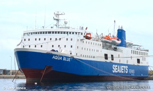
 Aqua Blue
Current Status
Where is the vessel?
Aqua Blue is currently in Near LIMNOS, based on AIS data received about 2h ago.
Latest AIS update:
Current position: 39.87195° N, 25.05421° E (Near LIMNOS)
Average speed (last 7 days): Loading…
Average speed (last 30 days): Loading…
Vessel profile: Aqua Blue is a Passenger Ro Ro Cargo Ship with dimensions 137m x 22m.
This page combines live AIS, route history, probable destination signals, nearby traffic, and port activity for practical vessel monitoring.
The current position of vessel Aqua Blue is 39.87195 lat / 25.05421 lng. Updated: 2026-04-14 23:43:27 UTCNearest reference points:
- 20 nm S of Ágios Efstrátios
- 16 nm NW of Sigri Lesvou
- 14 nm SW of Bozcaada
Currently sailing under the flag of Greece ![]()
Aqua Blue built in 1975 year
Deadweight:
2250 tDetails:
Live Vessel Aqua Blue Analytics (details, animations, etc.)
Recent AIS points (UTC):
2026-04-14 18:22:28 UTC · 40.93143, 24.41111 · SOG 0 kn · COG 261°2026-04-14 19:49:30 UTC · 40.76479, 24.45380 · SOG 18.1 kn · COG 158°
2026-04-14 22:14:47 UTC · 40.10388, 24.86392 · SOG 18.2 kn · COG 145°
2026-04-14 23:43:27 UTC · 39.87195, 25.05421 · SOG 0 kn · COG 327°