 vesseltracker.com
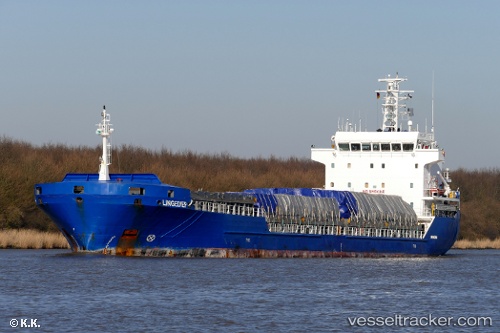
Vessel Manisa Bella IMO: 9421075, MMSI: 244630729 Multi Purpose Carrier
UTC, 38.67833, -9.18500, course: -1, speed: 0
UTC, 38.67833, -9.18500, course: -1, speed: 0
2026-03-03 08:18:15 UTC, 38.67917, -9.18559, course: -1, speed: 0
Live AIS position:
UTC. Near Banatica),
updated 2026-03-03 08:18:15 UTC.
Find the position of the vessel Manisa Bella on the map. The latter are known coordinates and path.
marine traffic ship tracker show on live map
The current position of vessel Manisa Bella is 38.67917 lat / -9.18559 lng. Updated: 2026-03-03 08:18:15 UTCCurrently sailing under the flag of Netherlands
Manisa Bella built in 2008 year
Deadweight:
8112 tDetails:
Last coordinates of the vessel:
UTC, 38.67833, -9.18500, course: -1, speed: 0UTC, 38.67833, -9.18500, course: -1, speed: 0
UTC, 38.67833, -9.18500, course: -1, speed: 0
2026-03-03 08:18:15 UTC, 38.67917, -9.18559, course: -1, speed: 0