 vesseltracker.com
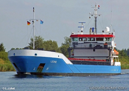
 Leonie
Current Status
Where is the vessel?
Leonie is currently in 30 nm S of Havdhem, based on AIS data received about 1h ago.
Latest AIS update:
Current position: 56.69238° N, 18.00491° E (30 nm S of Havdhem)
Average speed (last 7 days): Loading…
Average speed (last 30 days): Loading…
Vessel profile: Leonie is a Multi Purpose Carrier with dimensions 90m x 90m.
This page combines live AIS, route history, probable destination signals, nearby traffic, and port activity for practical vessel monitoring.
The current position of vessel Leonie is 56.69238 lat / 18.00491 lng. Updated: 2026-04-17 03:44:24 UTCNearest reference points:
- Near WLADYSLAWOWO
- 39 nm W of Pilies juru uosto PVP/Klaipeda
- Near Gdynia
Currently sailing under the flag of Netherlands ![]()
Leonie built in 2007 year
Deadweight:
3638 tDetails:
Live Vessel Leonie Analytics (details, animations, etc.)
Recent AIS points (UTC):
2026-04-16 21:58:24 UTC · 57.39371, 19.14486 · SOG 9.9 kn · COG 206°2026-04-16 23:26:05 UTC · 57.19351, 18.90160 · SOG 9.9 kn · COG 218°
2026-04-17 02:36:15 UTC · 56.80513, 18.27251 · SOG 9.7 kn · COG 231°
2026-04-17 03:44:24 UTC · 56.69238, 18.00491 · SOG 9.8 kn · COG 231°