 vesseltracker.com
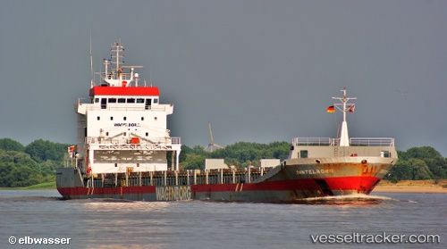
 Dintelborg
Current Status
Where is the vessel?
Dintelborg is currently in 19 nm NW of Lokken, based on AIS data received about 1h ago.
Latest AIS update:
Current position: 57.57583° N, 9.29510° E (19 nm NW of Lokken)
Average speed (last 7 days): Loading…
Average speed (last 30 days): Loading…
Vessel profile: Dintelborg is a General Cargo Ship with dimensions 133m x 15m.
This page combines live AIS, route history, probable destination signals, nearby traffic, and port activity for practical vessel monitoring.
The current position of vessel Dintelborg is 57.57583 lat / 9.29510 lng. Updated: 2026-04-07 17:50:54 UTCNearest reference points:
- 28 nm NW of Lokken
- 27 nm N of HANSTHOLM
- Near Hirtshals
Currently sailing under the flag of Netherlands ![]()
Dintelborg built in 1999 year
Deadweight:
8865 tDetails:
Live Vessel Dintelborg Analytics (details, animations, etc.)
Recent AIS points (UTC):
2026-04-07 16:22:03 UTC · 57.73095, 9.70921 · SOG 11.1 kn · COG 231°2026-04-07 16:22:03 UTC · 57.73095, 9.70921 · SOG 11.1 kn · COG 231°
2026-04-07 17:50:54 UTC · 57.57583, 9.29510 · SOG 11 kn · COG 233°
2026-04-07 17:50:54 UTC · 57.57583, 9.29510 · SOG 11 kn · COG 233°