 vesseltracker.com
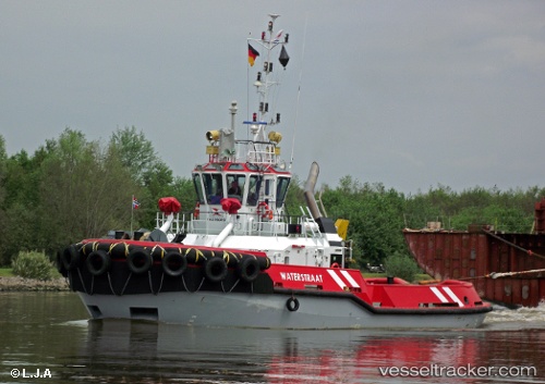
Vessel Waterstraat IMO: 9428059, MMSI: 246758000 Tug
UTC, 53.33063, 6.93206, course: -1, speed: 0
UTC, 53.32167, 7.00833, course: -1, speed: 9
2026-03-08 05:31:28 UTC, 53.33056, 6.93204, course: -1, speed: 0
Live Vessel Waterstraat Analytics (details, animations, etc.)
Live AIS position: UTC. Near Delfzijl), updated 2026-03-08 05:31:28 UTC.Find the position of the vessel Waterstraat on the map. The latter are known coordinates and path.
marine traffic ship tracker show on live map
The current position of vessel Waterstraat is 53.33056 lat / 6.93204 lng. Updated: 2026-03-08 05:31:28 UTCCurrently sailing under the flag of Netherlands
Waterstraat built in 2008 year
Deadweight:
149 tDetails:
Last coordinates of the vessel:
UTC, 53.33056, 6.93199, course: -1, speed: 0UTC, 53.33063, 6.93206, course: -1, speed: 0
UTC, 53.32167, 7.00833, course: -1, speed: 9
2026-03-08 05:31:28 UTC, 53.33056, 6.93204, course: -1, speed: 0