 vesseltracker.com
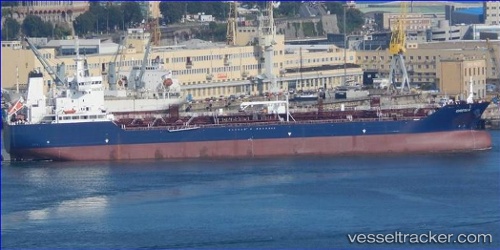
 Greta K
Current Status
Where is the vessel?
Greta K is currently in Near CORUNA, based on AIS data received about 1h ago.
Latest AIS update:
Current position: 43.35635° N, 8.38119° W (Near CORUNA)
Average speed (last 7 days): Loading…
Average speed (last 30 days): Loading…
Vessel profile: Greta K is a Chemical Oil Products Tanker with dimensions 158m x 26m.
This page combines live AIS, route history, probable destination signals, nearby traffic, and port activity for practical vessel monitoring.
The current position of vessel Greta K is 43.35635 lat / -8.38119 lng. Updated: 2026-04-05 05:35:59 UTCNearest reference points:
- Near La Coruna
- Near PUNTA LANGOSTEIRA
- Near Ferrol
Currently sailing under the flag of Malta ![]()
Details:
Live Vessel Greta K Analytics (details, animations, etc.)
Recent AIS points (UTC):
2026-04-04 23:38:56 UTC · 43.35637, -8.38118 · SOG 0 kn · COG 52°2026-04-05 02:26:57 UTC · 43.35635, -8.38118 · SOG 0 kn · COG 52°
2026-04-05 03:27:01 UTC · 43.35635, -8.38117 · SOG 0 kn · COG 52°
2026-04-05 05:35:59 UTC · 43.35635, -8.38119 · SOG 0 kn · COG 52°