 vesseltracker.com
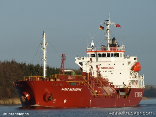
 B Gas Margrethe
Current Status
Where is the vessel?
B Gas Margrethe is currently in Near Port-Jérôme, based on AIS data received less than 1h ago.
Latest AIS update:
Current position: 49.46724° N, 0.54087° E (Near Port-Jérôme)
Average speed (last 7 days): Loading…
Average speed (last 30 days): Loading…
Vessel profile: B Gas Margrethe is a Lpg Tanker with dimensions 100m x 17m.
This page combines live AIS, route history, probable destination signals, nearby traffic, and port activity for practical vessel monitoring.
The current position of vessel B Gas Margrethe is 49.46724 lat / 0.54087 lng. Updated: 2026-03-29 23:49:08 UTCNearest reference points:
- Near Le Havre
- Near TROUVILLE-SUR-MER
- Near Le Grand-Quevilly
Currently sailing under the flag of Malta ![]()
B Gas Margrethe built in 2006 year
Deadweight:
4970 tDetails:
Live Vessel B Gas Margrethe Analytics (details, animations, etc.)
Recent AIS points (UTC):
2026-03-29 18:22:08 UTC · 49.46723, 0.54087 · SOG 0 kn · COG 320°2026-03-29 20:13:09 UTC · 49.46720, 0.54080 · SOG 0 kn · COG 321°
2026-03-29 21:34:14 UTC · 49.46722, 0.54086 · SOG 0 kn · COG 321°
2026-03-29 23:49:08 UTC · 49.46724, 0.54087 · SOG 0 kn · COG 320°