 vesseltracker.com
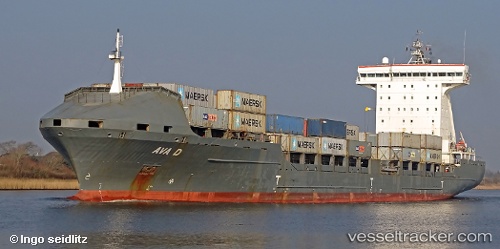
 AVA D
AVA D
Current Status
Where is the vessel?
AVA D is currently in Near Nowy Port/Gdansk, based on AIS data received less than 1h ago.
Latest AIS update:
Current position: 54.39420° N, 18.71993° E (Near Nowy Port/Gdansk)
Average speed (last 7 days): Loading…
Average speed (last 30 days): Loading…
Vessel profile: AVA D is a Container Ship with dimensions 168m x 26m.
This page combines live AIS, route history, probable destination signals, nearby traffic, and port activity for practical vessel monitoring.
The current position of vessel AVA D is 54.39420 lat / 18.71993 lng. Updated: 2026-03-31 02:00:49 UTCNearest reference points:
- Near Górki Zachodnie
- Near Nowy Port/Gdansk
- Near Sopot
Currently sailing under the flag of Portugal (MAR) ![]()
AVA D built in 2007 year
Deadweight:
20646 tDetails:
Live Vessel AVA D Analytics (details, animations, etc.)
Recent AIS points (UTC):
2026-03-30 20:03:06 UTC · 54.38616, 18.71674 · SOG 0 kn · COG 220°2026-03-30 21:57:07 UTC · 54.38616, 18.71671 · SOG 0 kn · COG 220°
2026-03-30 23:54:07 UTC · 54.38614, 18.71676 · SOG 0 kn · COG 220°
2026-03-31 02:00:49 UTC · 54.39420, 18.71993 · SOG 7 kn · COG 2°