 vesseltracker.com
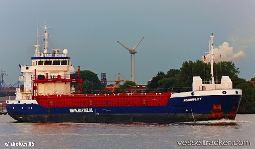
 NOORDVLIET
Current Status
Where is the vessel?
NOORDVLIET is currently in 27 nm NW of Dellys, based on AIS data received about 1h ago.
Latest AIS update:
Current position: 37.21921° N, 3.47423° E (27 nm NW of Dellys)
Average speed (last 7 days): Loading…
Average speed (last 30 days): Loading…
Vessel profile: NOORDVLIET is a General Cargo Ship with dimensions 89m x 13m.
This page combines live AIS, route history, probable destination signals, nearby traffic, and port activity for practical vessel monitoring.
The current position of vessel NOORDVLIET is 37.21921 lat / 3.47423 lng. Updated: 2026-04-05 01:48:26 UTCNearest reference points:
- 16 nm NE of Berja
- Near Algiers
- Near Zamoranos
Currently sailing under the flag of Portugal (MAR) ![]()
NOORDVLIET built in 2013 year
Deadweight:
3850 tDetails:
Live Vessel NOORDVLIET Analytics (details, animations, etc.)
Recent AIS points (UTC):
2026-04-04 20:01:47 UTC · 37.32787, 4.47652 · SOG 8.9 kn · COG 260°2026-04-04 22:18:37 UTC · 37.29514, 4.06862 · SOG 8.3 kn · COG 260°
2026-04-04 23:32:27 UTC · 37.27138, 3.86416 · SOG 8.3 kn · COG 260°
2026-04-05 01:48:26 UTC · 37.21921, 3.47423 · SOG 8.2 kn · COG 260°