 vesseltracker.com
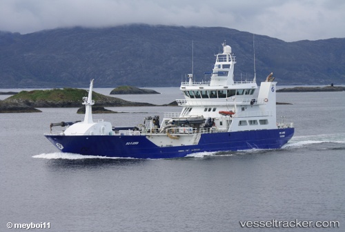
 Ro Fjord
Current Status
Where is the vessel?
Ro Fjord is currently in Near Mjølstadneset, based on AIS data received about 3h ago.
Latest AIS update:
Current position: 62.32165° N, 5.65622° E (Near Mjølstadneset)
Average speed (last 7 days): Loading…
Average speed (last 30 days): Loading…
Vessel profile: Ro Fjord is a Fish Carrier with dimensions 72m x 15m.
This page combines live AIS, route history, probable destination signals, nearby traffic, and port activity for practical vessel monitoring.
The current position of vessel Ro Fjord is 62.32165 lat / 5.65622 lng. Updated: 2026-04-08 19:24:50 UTCNearest reference points:
- Near Larsnes
- Near Gursken
- Near Alesund
Currently sailing under the flag of Norway ![]()
Ro Fjord built in 2010 year
Deadweight:
3100 tDetails:
Live Vessel Ro Fjord Analytics (details, animations, etc.)
Recent AIS points (UTC):
2026-04-08 14:02:10 UTC · 62.32158, 5.65630 · SOG 0 kn · COG 273°2026-04-08 16:11:40 UTC · 62.32161, 5.65623 · SOG 0 kn · COG 273°
2026-04-08 17:39:59 UTC · 62.32161, 5.65627 · SOG 0 kn · COG 273°
2026-04-08 19:24:50 UTC · 62.32165, 5.65622 · SOG 0 kn · COG 273°