 vesseltracker.com
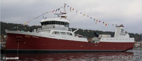
Vessel Doennland IMO: 9632569, MMSI: 257797000 Fishing Vessel
UTC, 68.23238, 14.53713, course: -1, speed: 0
UTC, 68.23236, 14.53712, course: -1, speed: 0
2026-02-01 18:17:01 UTC, 68.23234, 14.53712, course: -1, speed: 0
Live AIS position:
UTC. Near Svolvær Osan),
updated 2026-02-01 18:17:01 UTC.
Find the position of the vessel Doennland on the map. The latter are known coordinates and path.
marine traffic ship tracker show on live map
The current position of vessel Doennland is 68.23234 lat / 14.53712 lng. Updated: 2026-02-01 18:17:01 UTCCurrently sailing under the flag of Norway
Doennland built in 2012 year
Deadweight:
3000 tDetails:
Last coordinates of the vessel:
UTC, 68.23237, 14.53712, course: -1, speed: 0UTC, 68.23238, 14.53713, course: -1, speed: 0
UTC, 68.23236, 14.53712, course: -1, speed: 0
2026-02-01 18:17:01 UTC, 68.23234, 14.53712, course: -1, speed: 0