 vesseltracker.com
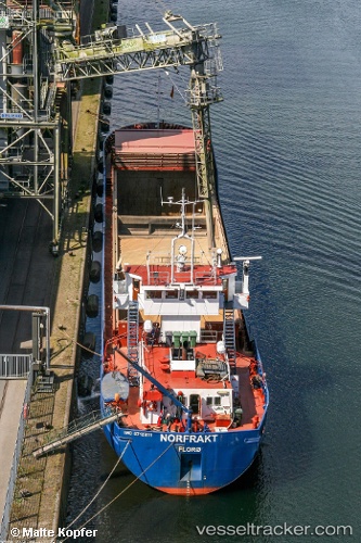
 Norfrakt
Current Status
Where is the vessel?
Norfrakt is currently in Near FEDJE, based on AIS data received about 2h ago.
Latest AIS update:
Current position: 60.89311° N, 4.48196° E (Near FEDJE)
Average speed (last 7 days): Loading…
Average speed (last 30 days): Loading…
Vessel profile: Norfrakt is a Multi Purpose Carrier with dimensions 74m x 12m.
This page combines live AIS, route history, probable destination signals, nearby traffic, and port activity for practical vessel monitoring.
The current position of vessel Norfrakt is 60.89311 lat / 4.48196 lng. Updated: 2026-03-27 12:01:02 UTCNearest reference points:
- Near Solund
- Near Eivindvik
- Near Hakonsvern
Currently sailing under the flag of Norway ![]()
Norfrakt built in 1988 year
Deadweight:
2181 tDetails:
Live Vessel Norfrakt Analytics (details, animations, etc.)
Recent AIS points (UTC):
2026-03-27 06:22:52 UTC · 59.97840, 4.77398 · SOG 9.2 kn · COG 349°2026-03-27 07:57:12 UTC · 60.22053, 4.69581 · SOG 9.6 kn · COG 352°
2026-03-27 10:11:51 UTC · 60.58847, 4.57331 · SOG 9.5 kn · COG 352°
2026-03-27 12:01:02 UTC · 60.89311, 4.48196 · SOG 9.7 kn · COG 352°