 vesseltracker.com
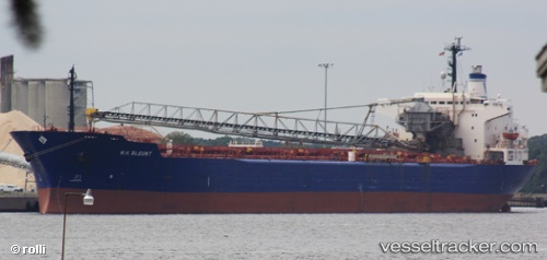
 Bontrup Amsterdam
Current Status
Where is the vessel?
Bontrup Amsterdam is currently in Near Bar Light, based on AIS data received about 1h ago.
Latest AIS update:
Current position: 53.54015° N, 3.32140° W (Near Bar Light)
Average speed (last 7 days): Loading…
Average speed (last 30 days): Loading…
Vessel profile: Bontrup Amsterdam is a Self Discharging Bulk Carrier with dimensions 225m x 32m.
This page combines live AIS, route history, probable destination signals, nearby traffic, and port activity for practical vessel monitoring.
The current position of vessel Bontrup Amsterdam is 53.54015 lat / -3.32140 lng. Updated: 2026-04-02 11:27:03 UTCNearest reference points:
- Near LIVERPOOL ANCH
- Near BIRKENHEAD
- Near ELLESMERE
Currently sailing under the flag of Bahamas ![]()
Bontrup Amsterdam built in 1984 year
Deadweight:
59960 tDetails:
Live Vessel Bontrup Amsterdam Analytics (details, animations, etc.)
Recent AIS points (UTC):
2026-04-02 05:44:04 UTC · 53.46066, -3.03139 · SOG 0 kn · COG 322°2026-04-02 08:02:02 UTC · 53.46063, -3.03138 · SOG 0 kn · COG 321°
2026-04-02 10:10:25 UTC · 53.46882, -3.05673 · SOG 7.8 kn · COG 318°
2026-04-02 11:27:03 UTC · 53.54015, -3.32140 · SOG 10.9 kn · COG 285°