 vesseltracker.com
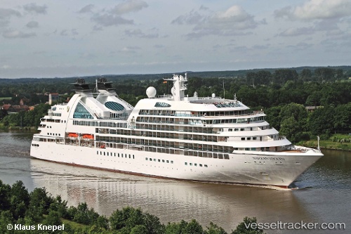
Vessel SEABOURN SOJOURN IMO: 9417098, MMSI: 311027100 Passenger Ship
UTC, 21.61380, -158.84695, course: 309, speed: 12.2
UTC, 21.95450, -159.34262, course: 281, speed: 5.4
2026-01-14 18:14:32 UTC, 21.95457, -159.35512, course: 74, speed: 0
Live AIS position:
UTC. Near NAWILIWILI),
updated 2026-01-14 18:14:32 UTC.
Find the position of the vessel SEABOURN SOJOURN on the map. The latter are known coordinates and path.
marine traffic ship tracker show on live map
The current position of vessel SEABOURN SOJOURN is 21.95457 lat / -159.35512 lng. Updated: 2026-01-14 18:14:32 UTCCurrently sailing under the flag of Bahamas
SEABOURN SOJOURN built in 2010 year
Deadweight:
3780 tDetails:
Last coordinates of the vessel:
UTC, 21.52060, -158.72806, course: 309, speed: 12.2UTC, 21.61380, -158.84695, course: 309, speed: 12.2
UTC, 21.95450, -159.34262, course: 281, speed: 5.4
2026-01-14 18:14:32 UTC, 21.95457, -159.35512, course: 74, speed: 0