 vesseltracker.com
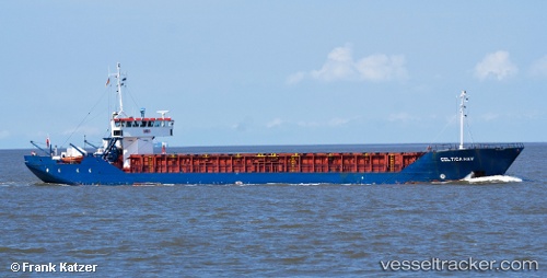
 Celtica Hav
Current Status
Where is the vessel?
Celtica Hav is currently in Near Falmouth, based on AIS data received about 2h ago.
Latest AIS update:
Current position: 50.15654° N, 5.05795° W (Near Falmouth)
Average speed (last 7 days): Loading…
Average speed (last 30 days): Loading…
Vessel profile: Celtica Hav is a Multi Purpose Carrier with dimensions 82m x 11m.
This page combines live AIS, route history, probable destination signals, nearby traffic, and port activity for practical vessel monitoring.
The current position of vessel Celtica Hav is 50.15654 lat / -5.05795 lng. Updated: 2026-04-10 05:19:48 UTCNearest reference points:
- Near Falmouth
- Near Flushing
- Near Cadgwith
Currently sailing under the flag of Bahamas ![]()
Celtica Hav built in 1984 year
Deadweight:
1720 tDetails:
Live Vessel Celtica Hav Analytics (details, animations, etc.)
Recent AIS points (UTC):
2026-04-10 00:31:35 UTC · 50.15654, -5.05792 · SOG 0 kn · COG 267°2026-04-10 02:36:42 UTC · 50.15655, -5.05792 · SOG 0 kn · COG 267°
2026-04-10 04:17:48 UTC · 50.15655, -5.05792 · SOG 0 kn · COG 267°
2026-04-10 05:19:48 UTC · 50.15654, -5.05795 · SOG 0 kn · COG 267°