 vesseltracker.com
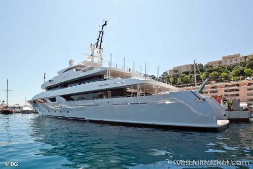
 TALEYA
Current Status
Where is the vessel?
TALEYA is currently in Near Zadar, based on AIS data received about 1h ago.
Latest AIS update:
Current position: 44.11911° N, 15.22527° E (Near Zadar)
Average speed (last 7 days): Loading…
Average speed (last 30 days): Loading…
Vessel profile: TALEYA is a Houseboat with dimensions 10m x 54m.
This page combines live AIS, route history, probable destination signals, nearby traffic, and port activity for practical vessel monitoring.
The current position of vessel TALEYA is 44.11911 lat / 15.22527 lng. Updated: 2026-04-05 04:02:08 UTCNearest reference points:
- Near GAZENICA
- Near Zadar
- Near Pasman
Currently sailing under the flag of Cayman Islands ![]()
TALEYA built in 2008 year
Deadweight:
0 tDetails:
Live Vessel TALEYA Analytics (details, animations, etc.)
Recent AIS points (UTC):
2026-04-04 22:17:05 UTC · 44.11912, 15.22527 · SOG 0 kn · COG 122°2026-04-04 23:32:06 UTC · 44.11910, 15.22526 · SOG 0 kn · COG 122°
2026-04-05 01:44:07 UTC · 44.11913, 15.22526 · SOG 0 kn · COG 121°
2026-04-05 04:02:08 UTC · 44.11911, 15.22527 · SOG 0 kn · COG 121°