 vesseltracker.com
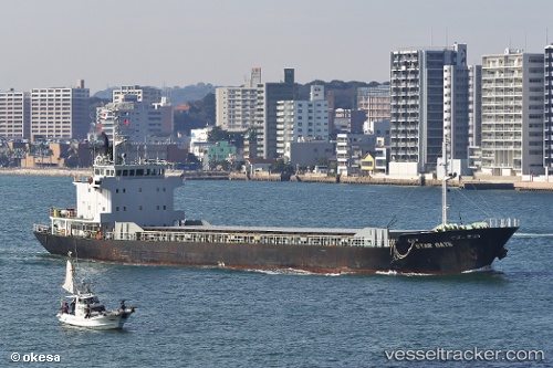
 Star Gate
Current Status
Where is the vessel?
Star Gate is currently in Near CHIBA, based on AIS data received about 1h ago.
Latest AIS update:
Current position: 35.59562° N, 139.99649° E (Near CHIBA)
Average speed (last 7 days): Loading…
Average speed (last 30 days): Loading…
Vessel profile: Star Gate is a Limestone Carrier with dimensions 91m x 14m.
This page combines live AIS, route history, probable destination signals, nearby traffic, and port activity for practical vessel monitoring.
The current position of vessel Star Gate is 35.59562 lat / 139.99649 lng. Updated: 2026-04-08 03:29:41 UTCNearest reference points:
- Near ANEGASAKI
- Near Aomi
- Near Kawasaki
Currently sailing under the flag of Panama ![]()
Star Gate built in 1991 year
Deadweight:
3488 tDetails:
Live Vessel Star Gate Analytics (details, animations, etc.)
Recent AIS points (UTC):
2026-04-07 21:50:51 UTC · 35.59598, 139.99741 · SOG 0.1 kn · COG 318°2026-04-07 23:51:51 UTC · 35.59581, 139.99722 · SOG 0.1 kn · COG 325°
2026-04-08 01:32:00 UTC · 35.59566, 139.99690 · SOG 0.1 kn · COG 340°
2026-04-08 03:29:41 UTC · 35.59562, 139.99649 · SOG 0 kn · COG 5°