 vesseltracker.com
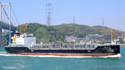
 Kinryu Maru
Current Status
Where is the vessel?
Kinryu Maru is currently in Near SENDAI, based on AIS data received about 2h ago.
Latest AIS update:
Current position: 38.22918° N, 141.09213° E (Near SENDAI)
Average speed (last 7 days): Loading…
Average speed (last 30 days): Loading…
Vessel profile: Kinryu Maru is a Chemical Oil Products Tanker with dimensions 105m x 16m.
This page combines live AIS, route history, probable destination signals, nearby traffic, and port activity for practical vessel monitoring.
The current position of vessel Kinryu Maru is 38.22918 lat / 141.09213 lng. Updated: 2026-03-27 21:53:12 UTCNearest reference points:
- Near Shiogama
- Near ISHINOMAKI
- Near ONAGAWA
Currently sailing under the flag of Japan ![]()
Details:
Live Vessel Kinryu Maru Analytics (details, animations, etc.)
Recent AIS points (UTC):
2026-03-27 15:59:12 UTC · 38.22940, 141.09241 · SOG 0.1 kn · COG 93°2026-03-27 17:41:12 UTC · 38.22932, 141.09216 · SOG 0.1 kn · COG 96°
2026-03-27 20:05:12 UTC · 38.22899, 141.09213 · SOG 0 kn · COG 75°
2026-03-27 21:53:12 UTC · 38.22918, 141.09213 · SOG 0.1 kn · COG 85°