 vesseltracker.com
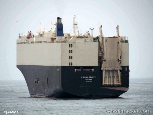
 K. ASIAN BEAUTY
Current Status
Where is the vessel?
K. ASIAN BEAUTY is currently in Near Westport/Port Klang, based on AIS data received about 1h ago.
Latest AIS update:
Current position: 2.95111° N, 101.30369° E (Near Westport/Port Klang)
Average speed (last 7 days): Loading…
Average speed (last 30 days): Loading…
Vessel profile: K. ASIAN BEAUTY is a Vehicles Carrier with dimensions 31m x 184m.
This page combines live AIS, route history, probable destination signals, nearby traffic, and port activity for practical vessel monitoring.
The current position of vessel K. ASIAN BEAUTY is 2.95111 lat / 101.30369 lng. Updated: 2026-04-06 16:06:30 UTCNearest reference points:
- Near Westport/Port Klang
- Near PORT KLANG
- Near Port Klang (Ferry Port)
Currently sailing under the flag of Korea (Republic of) ![]()
K. ASIAN BEAUTY built in 1994 year
Deadweight:
13308 tDetails:
Live Vessel K. ASIAN BEAUTY Analytics (details, animations, etc.)
Recent AIS points (UTC):
2026-04-06 09:49:37 UTC · 2.83554, 101.25361 · SOG 9.5 kn · COG 6°2026-04-06 11:27:31 UTC · 2.95110, 101.30367 · SOG 0 kn · COG 32°
2026-04-06 13:57:30 UTC · 2.95113, 101.30367 · SOG 0 kn · COG 32°
2026-04-06 16:06:30 UTC · 2.95111, 101.30369 · SOG 0 kn · COG 32°